GeoJSON in action: A practical guide for automotive

In today's data-driven world, the ability to accurately represent and analyze geographic information is crucial for various fields, from urban planning and environmental monitoring to navigation and location-based services. GeoJSON, a versatile and human-readable data format, has emerged as a global standard for encoding geographic data structures. This powerful tool allows users to seamlessly store and exchange geospatial data such as points, lines, and polygons, along with their attributes like names, descriptions, and addresses.
GeoJSON leverages the simplicity of JSON (JavaScript Object Notation), making it not only easy to understand and use but also compatible with a wide array of software and web applications. This adaptability is especially beneficial in the automotive industry, where precise geospatial data is essential for developing advanced navigation systems , autonomous vehicles, and location-based services that enhance the driving experience.
As we explore the complexities of GeoJSON, we will examine its syntax, structure, and various applications. Whether you’re an experienced GIS professional, a developer in the automotive industry , or simply a tech enthusiast, this article aims to equip you with a thorough understanding of GeoJSON and its significant impact on geographic data representation.
Join us as we decode GeoJSON, uncovering its significance, practical uses, and the impact it has on our interaction with the world around us.
What is GeoJSON
GeoJSON is a widely used format for encoding a variety of geographic data structures using JavaScript Object Notation (JSON). It is designed to represent simple geographical features, along with their non-spatial attributes. GeoJSON supports different types of geometry objects and can include additional properties such as names, descriptions, and other metadata, making GeoJSON a versatile format for storing and sharing rich geographic information.
GeoJSON is based on JSON, a lightweight data-interchange format that is easy for humans to read and write and easy for machines to parse and generate. This makes GeoJSON both accessible and efficient, allowing it to be used across various platforms and applications.
GeoJSON also allows for the specification of coordinate reference systems and other parameters for geometric objects, ensuring that data can be accurately represented and interpreted across different systems and applications .
Due to its flexibility and ease of use, GeoJSON has become a standard format in geoinformatics and software development, especially in applications that require the visualization and analysis of geographic data. It is commonly used in web mapping, geographic information systems (GIS), mobile applications, and many other contexts where spatial data plays a critical role.
GeoJSON structure and syntax
As we already know, GeoJSON represents geographical data structure using JSON. It consists of several key components that make it versatile and widely used for representing geographical data. In this section, we will dive into the structure and syntax of GeoJSON, focusing on its primary components: Geometry Objects and Feature Objects . But first, we need to know what a position is.
Position is a fundamental geometry construct represented by a set of coordinates. These coordinates specify the exact location of a geographic feature. The coordinate values are used to define various geometric shapes, such as points, lines, and polygons. The position is always represented as an array of longitude and latitude like: [102.0, 10.5].
Geometry objects
Geometry objects are the building blocks of GeoJSON, representing the shapes and locations of geographic features. Each geometry object includes a type of property and a coordinates property. The following are the types of geometry objects supported by GeoJSON:
- Point
Point is the simplest GeoJSON object that represents a single geographic location on the map. It is defined by coordinates with a single pair of longitude and latitude .
Example:
{
    "type": "Point",
    "coordinates": [102.0, 0.5]
  }
- LineString
LineString represents a series of connected points (creating a path or route).
It is defined by an array of longitude and latitude pairs.
Example:
{
    "type": "LineString",
    "coordinates": [
      [102.0, 0.0],
      [103.0, 1.0],
      [104.0, 0.0]
    ]
  }
- Polygon
Polygon represents an area enclosed by one or more linear rings (or points) (a closed shape).
It is defined by an array of linear rings (or points), where the first one defines the outer boundary, and optional additional rings defines holes inside the polygon.
Example:
{
    "type": "Polygon",
    "coordinates": [
      [
        [100.0, 0.0],
        [101.0, 0.0],
        [101.0, 1.0],
        [100.0, 1.0],
        [100.0, 0.0]
      ]
    ]
  }
- MultiPoint
Represent multiple points on the map.
It is defined by an array of longitude and latitude pairs.
Example:
{
    "type": "MultiPoint",
    "coordinates": [
      [102.0, 0.0],
      [103.0, 1.0],
      [104.0, 2.0]
    ]
  }
- MultiLineString
Represents multiple lines, routes, or paths.
It is defined by an array of arrays, where each inner array represents a separate line.
Example:
{
    "type": "MultiLineString",
    "coordinates": [
      [
        [102.0, 0.0],
        [103.0, 1.0]
      ],
      [
        [104.0, 0.0],
        [105.0, 1.0]
      ]
    ]
  }
- MultiPolygon
Represents multiple polygons.
It is defined by an array of polygon arrays, each containing points for boundaries and holes.
Example:
{
    "type": "MultiPolygon",
    "coordinates": [
      [
        [
          [100.0, 0.0],
          [101.0, 0.0],
          [101.0, 1.0],
          [100.0, 1.0],
          [100.0, 0.0]
        ]
      ],
      [
        [
          [102.0, 0.0],
          [103.0, 0.0],
          [103.0, 1.0],
          [102.0, 1.0],
          [102.0, 0.0]
        ]
      ]
    ]
  }
Feature objects
Feature objects are used to represent spatially bounded entities. Each feature object includes a geometry object (which can be any of the geometry types mentioned above) and a properties object, which holds additional information about the feature.
In GeoJSON, a Feature object is a specific type of object that represents a single geographic feature. This includes the geometry object (such as point, line, polygon, or any other type we mentioned above) and associated properties like name, category, or other metadata.
- Feature
A Feature in GeoJSON represents a single geographic object along with its associated properties (metadata). It consists of three main components:
- Geometry : This defines the shape of the geographic object (e.g., point, line, polygon). It can be one of several types like "Point", "LineString", "Polygon", etc.
- Properties : A set of key-value pairs that provide additional information (metadata) about the feature. These properties are not spatial—they can include things like a name, population, or other attributes specific to the feature.
- ID (optional): An identifier that uniquely distinguishes this feature within a dataset.
Example of a GeoJSON Feature (a single point with properties):
{
    "type": "Feature",
    "geometry": {
      "type": "Point",
      "coordinates": [102.0, 0.5]
    },
    "properties": {
      "name": "Example Location",
      "category": "Tourist Spot"
    }
  }
- FeatureCollection
A FeatureCollection in GeoJSON is a collection of multiple Feature objects grouped together. It's essentially a list of features that share a common structure, allowing you to store and work with multiple geographic objects in one file.
FeatureCollection is used when you want to store or represent a group of geographic features in a single GeoJSON structure.
Example of a GeoJSON FeatureCollection (multiple features):
{
  "type": "FeatureCollection",
  "features": [
    {
      "type": "Feature",
      "geometry": {
        "type": "Point",
        "coordinates": [102.0, 0.5]
      },
      "properties": {
        "name": "Location A",
        "category": "Restaurant"
      }
    },
    {
      "type": "Feature",
      "geometry": {
        "type": "LineString",
        "coordinates": [
          [102.0, 0.0],
          [103.0, 1.0],
          [104.0, 0.0],
          [105.0, 1.0]
        ]
      },
      "properties": {
        "name": "Route 1",
        "type": "Road"
      }
    },
    {
      "type": "Feature",
      "geometry": {
        "type": "Polygon",
        "coordinates": [
          [
            [100.0, 0.0],
            [101.0, 0.0],
            [101.0, 1.0],
            [100.0, 1.0],
            [100.0, 0.0]
          ]
        ]
      },
      "properties": {
        "name": "Park Area",
        "type": "Public Park"
      }
    }
  ]
}
Real-world applications of GeoJSON for geographic data in various industries
GeoJSON plays a crucial role in powering a wide range of location-based services and industry solutions. From navigation systems like Google Maps to personalized marketing, geofencing, asset tracking, and smart city planning, GeoJSON's ability to represent geographic features in a simple, flexible format makes it an essential tool for modern businesses. This section explores practical implementations of GeoJSON across sectors, highlighting how its geometry objects—such as Points, LineStrings, and Polygons—are applied to solve real-world challenges.
Navigation systems
GeoJSON is fundamental in building navigation systems like Google Maps and Waze, where accurate geographic representation is key. In these systems, LineString geometries are used to define routes for driving, walking, or cycling. When a user requests directions, the route is mapped out using a series of coordinates that represent streets, highways, or pathways.
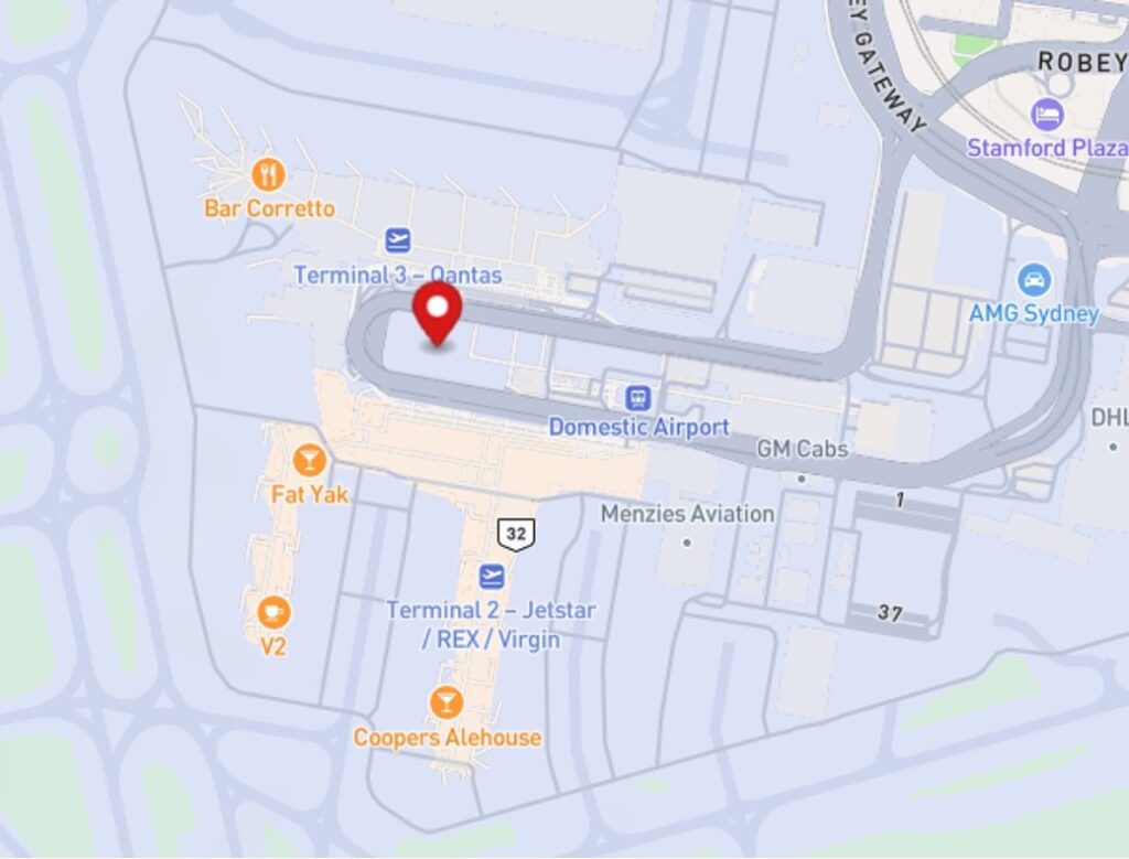
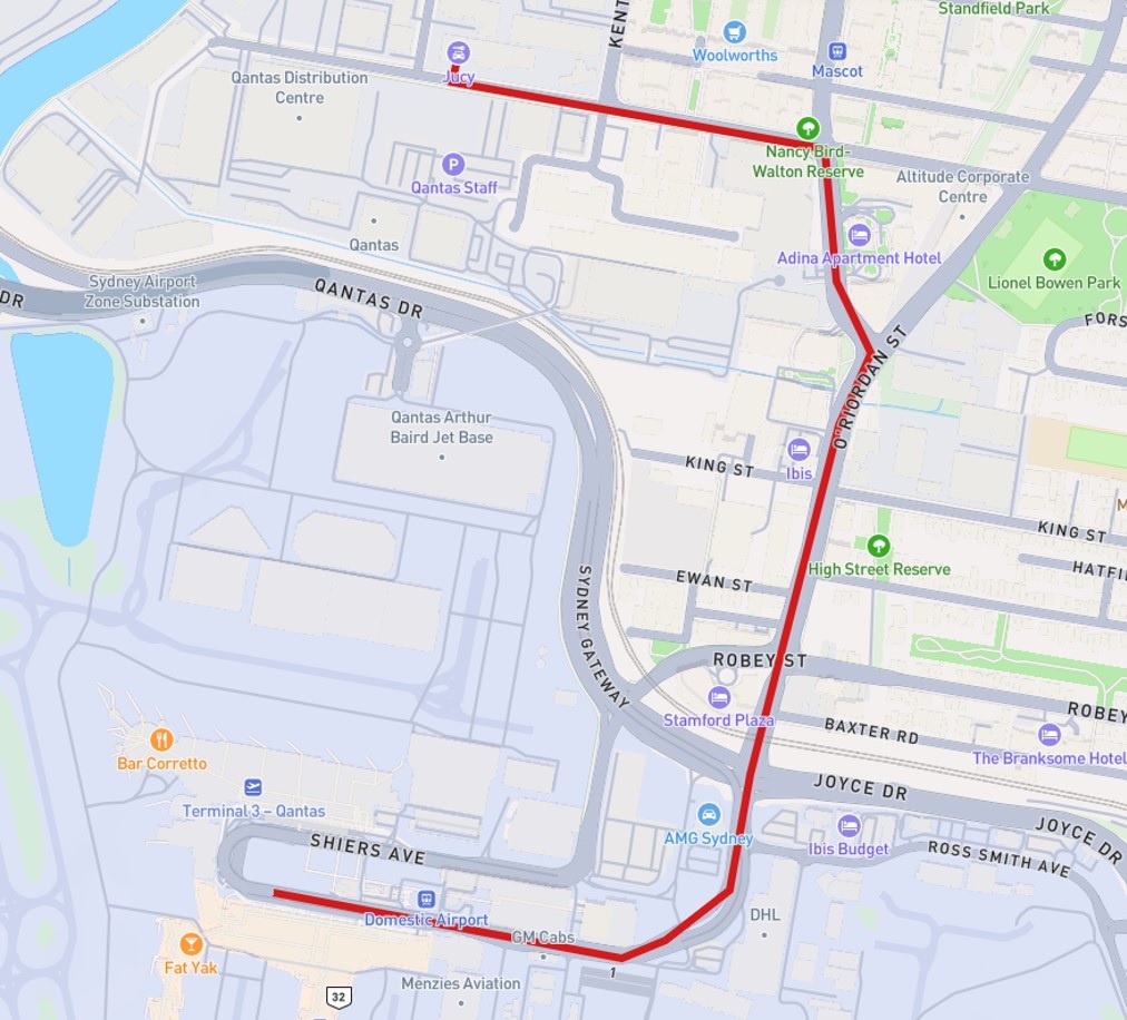
Points are employed to mark key locations such as starting points, destinations, and waypoints along the route. For instance, when you search for a restaurant, the result is displayed as a Point on the map. Additionally, real-time traffic data can be visualized using LineStrings to indicate road conditions like congestion or closures.
Navigation apps also leverage FeatureCollections to combine multiple geographic elements - routes, waypoints, and landmarks - into a cohesive dataset, allowing users to visualize the entire journey in one view.
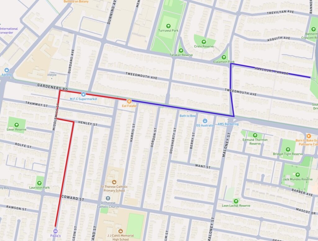
Speaking of those Geometry and Feature Objects , let’s go back to our examples of MultiPoints and MultiLineString and combine them together.
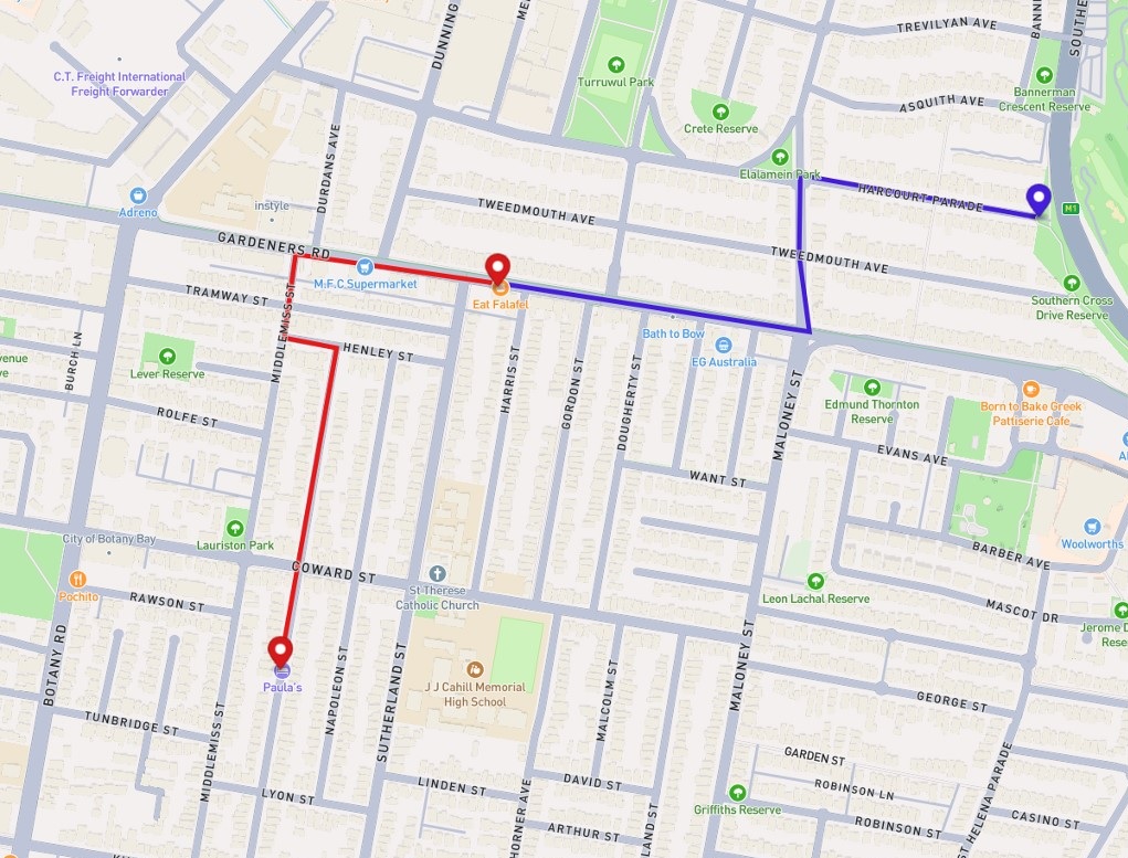
As a result, we receive a route with a starting point, stop, and final destination. Looks familiar, eh?
Geofencing applications
GeoJSON is a critical tool for implementing geofencing applications, where virtual boundaries are defined to trigger specific actions based on a user's or asset’s location. Polygons are typically used to represent these geofences, outlining areas such as delivery zones, restricted regions, or toll collection zones. For instance, food delivery services use Polygon geometries to define neighborhoods or areas where their service is available. When a customer's location falls within this boundary, the service becomes accessible.
In toll collection systems, Polygons outline paid areas like city congestion zones. When a vehicle crosses into these zones, geofencing triggers automatic toll payments based on location, offering drivers a seamless experience.
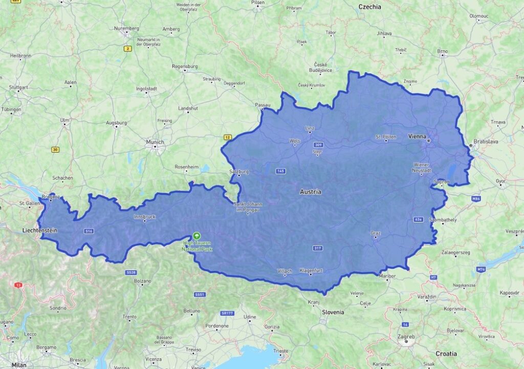
To use the highways in Austria, a vehicle must have a vignette purchased and properly stuck to its windshield. However, buying and sticking a vignette on the car can be time-consuming. This is where toll management systems can be beneficial. Such a system can create a geofenced Polygon representing the boundaries of Austria. When a user enters this polygon, their location is detected, allowing the system to automatically purchase an electronic vignette on their behalf.
Asset and fleet tracking
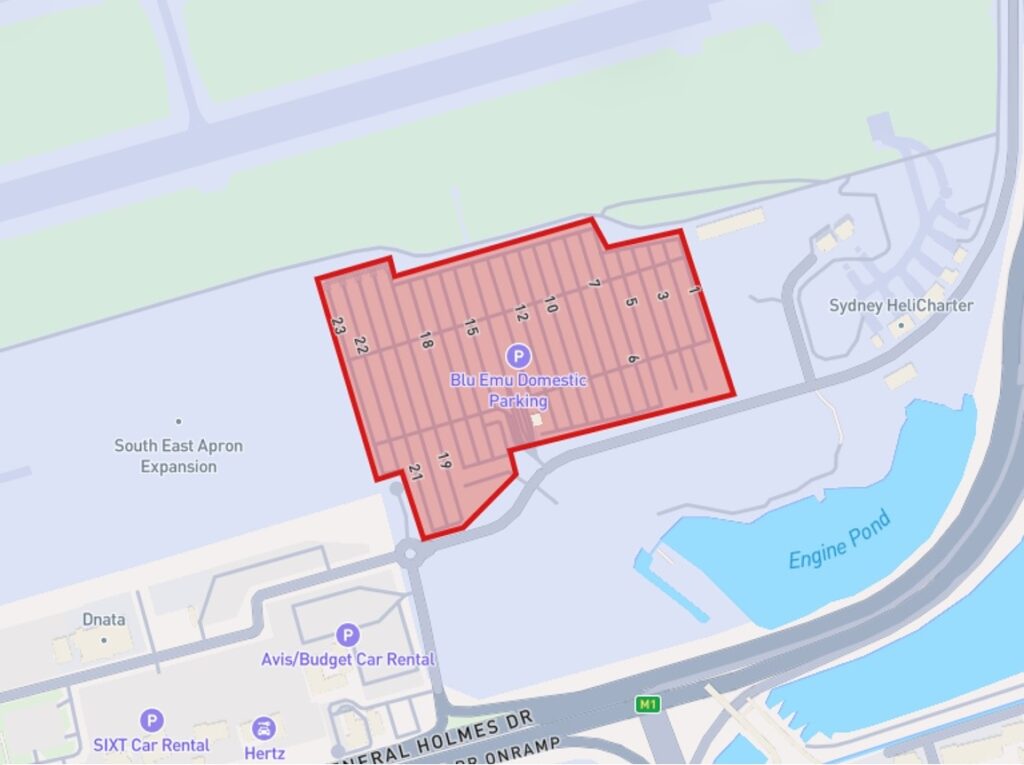
Additionally, geofencing is widely applied in asset and fleet tracking , where businesses monitor the real-time movement of vehicles, shipments, and other assets. Using Polygon geofences, companies can define key operational zones, such as warehouses, distribution centers, or delivery areas. When a vehicle or asset enters or exits these boundaries, alerts or automated actions are triggered, allowing seamless coordination and timely responses. For example, a logistics manager can receive notifications when a truck enters a distribution hub or leaves a specific delivery zone.
Points are utilized to continuously update the real-time location of each asset, allowing fleet managers to track vehicles as they move across cities or regions. This real-time visibility helps optimize delivery routes, reduce delays, and prevent unauthorized deviations. Additionally, LineStrings can be used to represent the path traveled by a vehicle, allowing managers to analyze route efficiency, monitor driver performance, and identify potential issues such as bottlenecks or inefficient paths.
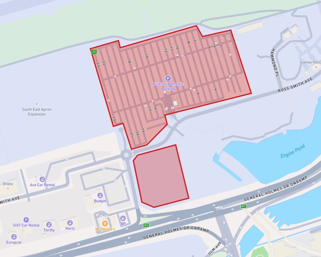
In the example below, we have a Polygon that represents a distribution area. Based on the fleet’s geolocation data, an action of a vehicle entering or leaving the zone can be triggered by providing live fleet monitoring.
Going further, we can use the vehicle’s geolocation data to present a detailed vehicle journey by mapping it to MultiLineString or present the most recent location with a Point.
Source: https://www.clearpathgps.com/blog/ways-geofences-improve-fleet-management
Location-based marketing
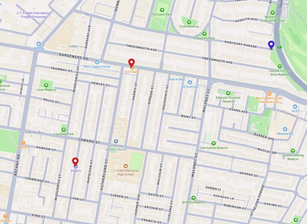
Location-based marketing utilizes geolocation data to deliver personalized advertisements and offers to consumers based on their real-time location. By defining Polygons as specific areas, businesses can trigger targeted promotions when a consumer enters these zones, encouraging visits to nearby stores with exclusive discounts or special events.
Retailers can also analyze foot traffic patterns to optimize store layouts and better understand customer movement. Platforms like Google Maps leverage this data to notify users of nearby attractions and offers. By harnessing geolocation data effectively, companies can enhance customer engagement and maximize their marketing efforts.
Conclusion
In summary, GeoJSON is a versatile and powerful format for encoding geographic data, enabling the representation of various geometric shapes and features essential for modern applications. Its structured syntax, encompassing geometry and feature objects, allows for effective communication of spatial information across multiple industries.
Real-world applications such as navigation systems, geofencing, and fleet tracking illustrate GeoJSON's capability to enhance efficiency and decision-making in transportation, marketing, and asset management.
As the demand for location-based services continues to grow, understanding and utilizing GeoJSON will be critical for businesses and organizations aiming to leverage geospatial data for innovative solutions.

Grape Up guides enterprises on their data-driven transformation journey
Ready to ship? Let's talk.
Check related articles
Read our blog and stay informed about the industry's latest trends and solutions.
Vehicle automation - where we are today and what problems we are facing
Tesla has Autopilot, Cadillac has Super Cruise, and Audi uses Travel Assist. While there are many names, their functionality is essentially similar. ADAS(advanced driver-assistance systems) assists the driver while on the road and sets the path we need to take toward autonomous driving. And where does your brand rank in terms of vehicle automation?
Consumers’ Reports data shows that 92 percent of new cars have the ability to automate speed with adaptive cruise control, and 50 percent can control both steering and speed. Although we are still two levels away from a vehicle that will be fully controlled by algorithms ( see the infographic below ), which, according to independent experts, is unlikely to happen within the next 10 years (at least when it comes to traditional car traffic), ADAS systems are finding their way into new vehicles year after year, and drivers are slowly learning to use them wisely.

On the six-step scale of vehicle automation - starting at level 0, where the vehicle is not equipped with any driving technology, and ending at level 5 (fully self-driving vehicle) - we are now at level 3. ADAS systems, which are in a way the foundation for a fully automated vehicle, combine automatic driving, acceleration, and braking solutions under one roof.
However, in order for this trend to be adopted by the market and grow dynamically year by year, we need to focus on functional software and the challenges facing the automotive industry .
The main threats facing automated driving support systems
1. The absence of a driver monitoring system
Well-designed for functionality and UX, ADAS can effectively reduce driver fatigue and stress during extended journeys. However, for this to happen it needs to be equipped with an effective driver monitoring system.
Why is this significant? With the transfer of some driving responsibility into the hands of advanced technology, the temptation to "mind their own business" can arise in the driver. And this often results in drivers scrolling through their social media feeds on their smartphones. When automating driving, it is important to involve the driver, who must be constantly aware that their presence is essential to driving.
Meanwhile, Consumer Reports, which surveyed dozens of such systems in vehicles from leading manufacturers, reports that just five of them: BMW, Ford, Tesla, GM and Subaru - have fitted ADAS with such technology.
According to William Wallace - safety policy manager at Consumer Reports, "The evidence is clear: if a car facilitates people’s distraction from the road, they will do it - with potentially fatal consequences. It's critical that active driving assistance systems have safety features that actually verify that drivers are paying attention and are ready to take action at all times. Otherwise, the safety risks of these systems may ultimately outweigh their benefits."
2. Lack of response to unexpected situations
According to the same institution, none of the systems tested reacted well to unforeseen situations on the road, such as construction, potholes, or dangerous objects on the roadway. Such deficiencies in functionality in current systems, therefore, create a potential risk of accidents, because even if the system guides the vehicle flawlessly along designated lanes (intermittent lane-keeping or sustained lane-keeping system) the vehicle will not warn the driver in time to take control of the car when it becomes necessary to readjust the route.
There are already existing solutions on the market that can effectively warn the driver of such occurrences, significantly increase driving comfort and "delegate" some tasks to intelligent software. These are definitely further elements on the list of things worth upgrading driving automation systems within the coming years.
3. Inadequate UX and non-intuitive user experience
All technological innovations at the beginning of their development breed resistance and misunderstanding. It's up to the manufacturer and the companies developing software to support vehicle automation to create systems that are straightforward and user-friendly. Having simple controls, clear displays and transparent feedback on what the system does with the vehicle is an absolute "must-have" for any system. The driver needs to understand right from the outset in which situations the system should be used when to take control of the vehicle and what the automation has to offer.
4. Lack of consistency in symbols and terminology
Understanding the benefits and functionality of ADAS systems is certainly not made easier by the lack of market consistency. Each of the leading vehicle manufacturers uses different terminology and symbols for displaying warnings in vehicles. The buyer of a new vehicle does not know if a system named by Toyota offers the same benefits as a completely different named system available from Ford or BMW and how far the automation goes.
Sensory overload affects driver frustration, misunderstanding of automation, or outright resentment, and this is reflected in consumer purchasing decisions and, thus, in the development of systems themselves. It is challenging to track their impact on safety and driving convenience when the industry has not developed uniform naming and consistent labeling to help enforce the necessary safety features and components of such systems.
5. System errors
Automation systems in passenger cars are fairly new and still in development. It's natural that in the early stages they can make mistakes and sometimes draw the wrong conclusions from the behavior of drivers or neighboring vehicles. Unfortunately, mistakes - like the ones listed below - cause drivers to disable parts of the system or even all of it because they simply don't know how to deal with it.
- Lane-keeping assists freaking out in poorer weather;
- Steering stiffening and automatically slowing down when trying to cross the line;
- Sudden acceleration or braking of a vehicle with active cruise control - such as during overtaking maneuvers or entering a curve on a highway exit or misreading signs on truck trailers.
How to avoid such errors? The solution is to develop more accurate models that detect which lanes are affected by signs or traffic lights.
Vehicle automation cannot happen automatically
Considering the number of potential challenges and risks that automakers face when automating vehicles, it's clear that we're only at the beginning of the road to the widespread adoption of these technologies. This is a defining moment for their further development, which lays the foundation for further action.
On the one hand, drivers are already beginning to trust them, use them with greater frequency, and expect them in new car models. On the other hand, many of these systems still have the typical flaws and shortcomings of "infancy," which means that with their misunderstanding or overconfidence in their capabilities, driver frustration can result, or in extreme cases, accidents. The role of automotive OEMs and software developers is to create solutions that are simple and intuitive and to listen to market feedback even more attentively than before. A gradual introduction of such solutions to the market, so that consumers have time to learn and grasp them, will certainly facilitate automation to a greater extent and ultimately the creation of fully automated vehicles. For now, the path leading to them is still long and bumpy.
Interested in our services?
Reach out for tailored solutions and expert guidance.